Tommy McNamara Trail Challenge

THE 2026 CHALLENGE HAS STARTED!
“Three towns, three schools, three land trusts, one community.”

Background Information
The Trail Challenge is a collaborative initiative developed by the Kennebunkport Conservation Trust, the Arundel Conservation Trust, and the Kennebunk Land Trust. This project aims to connect local youth in grades one through eight with the abundant natural beauty and recreational opportunities available in their own backyards. Through exploration and adventure, the Trail Challenge will inspire a lifelong appreciation for the outdoors, while strengthening community ties and promoting healthy, active lifestyles.
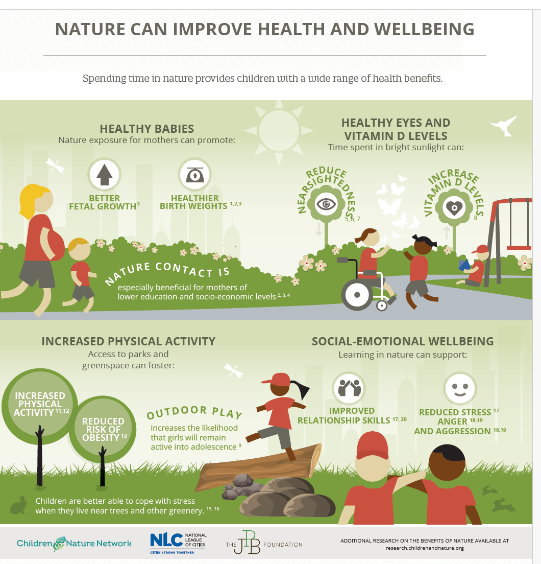
According to research, living in greener environments and engaging with nature can enhance children’s mental health and emotional well-being. For kids, this means more positive moods; improved ability to deal with stress; higher self-esteem; improved self-regulation; and more positive social interactions. In some cases, it’s the most vulnerable or marginalized children who can benefit most from nature. Even short, regular visits to natural spaces can lead to improved well-being and greater resilience—benefits that are especially important in today’s fast-paced, screen-dominated world.
The Trail Challenge will encourage children to explore 16 scenic trails across the Kennebunks. At each trailhead, participants will find a specially designated Tommy McNamara sign with a code word on the back. As each child hikes each trail, they’ll collect these code words in their nature journals to mark their progress, documenting their adventures and building a sense of accomplishment along the way.
This program reflects the shared missions of the partnering conservation trusts:
- The Arundel Conservation Trust (ACT) works to conserve Arundel's unique natural, recreational, and scenic resources to foster a strong, vibrant community. ACT believes in connecting people with the land and with each other through meaningful outdoor experiences.
- The Kennebunk Land Trust (KLT) has protected over 3,400 acres of diverse landscapes in Kennebunk—including forest, marsh, and farmland—offering countless opportunities for public recreation, education, and conservation stewardship.
- The Kennebunkport Conservation Trust (KCT) is dedicated to preserving and caring for land to educate and inspire, protect biodiversity, and connect people to the natural world through immersive experiences.
This initiative is inspired by the Tommy McNamara Charitable Foundation (TMCF). Founded in memory of Tommy McNamara—a vibrant and active young member of the Kennebunk community—the Foundation honors his legacy by supporting youth recreation. TMCF’s mission to develop and maintain high-quality recreational opportunities for local youth aligns seamlessly with the goals of the Trail Challenge. Tommy’s love for the outdoors, community, and exploration lives on through programs like this—encouraging young people to find joy in fresh air, friendship, and the freedom of the trails.
By promoting adventure and appreciation of the environment, the Trail Challenge will foster a stronger connection between local youth and the landscapes that define their home—laying the groundwork for a healthier, more engaged, and more environmentally conscious generation.
Trail Challenge Details
This challenge runs from June 5 to September 7, 2026, inviting youth participants to explore 16 designated trail locations across the Kennebunks. However, you only need to visit 10 out of the 16 trails to complete the challenge.
At each trailhead, you’ll find a sign with a code word on the back. Record these code words in your nature journal on the corresponding trail page.
Once you’ve collected 10 of the 16 codewords, complete the separate code word submission form by September 7th, 2026.
Earn a bug collection kit by visiting 10 or more trails!
The bug kit will be presented at Arundel Conservation Trust Trail Fest on September 26th at Arundel Community Trails—more details to come!
Note: Register by August 9th to guarantee your bug kit at the ceremony. If you register after August 9th, your bug kit will be available for pick-up at a later date.
After registering, participants can pick up their professionally printed nature journal, which includes pages to record special code words found at each trailhead. Journals can be picked up during normal business hours Monday - Friday at KCT Headquarters (57 Gravelly Brook Rd, Kennebunkport) or at the Kennebunk Land Trust (6 Brown St #2, Kennebunk). Feel free to give us a call to make sure someone is there, as we may be out in the field or in meetings off-site.
Register for the trail challenge here!
Participating Trails (read more info on each trail below)
- Kennebunkport Conservation Trust: Brook Trail, Fox Den Trail, Learning Trail, Storybook Trail, Jeremy’s Trail, Roller Trail, Batson River Trail (Tyler Brook Preserve), and Meadow Woods.
- Arundel Conservation Trust: Welch Woods, Yellow Community Trail, Red Community Trail, and the Roll Um Easy Trail
Kennebunk Land Trust: Wonder Brook Preserve Trail, For All Forever Preserve, Alewive Woods, and Tributary Preserve
Important Dates
June 5th: Challenge Begins
August 9th: Registration Closes
September 7th: Code word submission is due
September 26th: Join us for a special celebration at Arundel Community Trails, where we’ll honor all Trail Challenge participants and present a bug collection kit to those who completed the journey. Enjoy light refreshments, family-friendly activities, and the chance to connect with fellow trail explorers as we celebrate a summer of adventure and achievement at Arundel Conservation Trust’s 6th Annual Trail Fest.
Trail Descriptions and Locations
Smith Preserve - 76 Guinea Road, Kennebunkport Maine 04046
Google Maps / Smith Preserve Map
The Smith Preserve is the Trust's largest holding. It features over 1,100 acres, 10 miles of recreational trails, babbling brooks, picnic rocks, quaint bridges, and a gorgeous forested landscape. In addition to the trail system, the Smith Preserve is primarily a wildlife habitat. It is part of a 3,000 acre block of undeveloped land, the largest such piece between Kittery and Brunswick on the coast, and home to white-tailed deer, bobcats, coyotes, hares, owls, partridges, turtles, and many other species. For our human friends, the property is ideal for hiking, mountain biking, cross country skiing, snowshoeing, bird watching and peaceful getaways from our busy lives.
Fox Den Trail: 0.8 miles from Marker 2 to 5
Following straight on Steele Trail, take a right onto fox den trail
GPS Coordinates to trailhead: 43.42594, -70.46631
Brook Trail: 0.3 miles from Marker 2 to 3
Following straight on Steele Trail, take a hard left onto brook trail, almost backtracking
GPS Coordinates to trailhead: 43.42577, -70.46632
Emmons Preserve - 57 Gravelly Brook Road, Kennebunkport Maine 04046
Google Maps / Emmons Preserve Map
Located in the heart of Kennebunkport, the Emmons Preserve has become a vital part of our community. The site features the homestead of Steve and Natalie Emmons, which was generously donated to the Trust. Steve's dream was to have the property serve as a place for children to connect with nature. Over the years, KCT has built a beautiful headquarters building, established trails, and created a place for the people of Kennebunkport to gather.
Learning Trail
The Learning Trail is a 0.7 mile loop that runs through an evergreen forest as well as wetlands, with many explanatory signs describing the plants and animals you might encounter. Connected to the Batson River Trail, the Learning Trail passes by the Washburn Cemetery, and crosses the remains of a tote road, an old road once used for logging.
GPS Coordinates to trailhead: 43.4010626, -70.4532030
Storybook Trail
The Storybook trail is a short walk adjacent to the trust headquarters. Redesigned in May 2025, it features a book walk and sensory garden experience.
GPS Coordinates to trailhead: 43.4036608, -70.4529582 / Off of the lower parking lot to the right of the shedJeremy’s Trail
Jeremy’s Trail is a short loop (0.4 miles) that takes you through a white pine forest, scattered with Eastern hemlock trees. With a view of the Batson River, this trail is connected to Jenne’s Loop, the Batson River Trail, and Gravelly Brook Rd. Look for the trail head off of Gravelly Brook road with the red blazes and the parking space.
GPS Coordinates to trailhead: 43.4059785, -70.4573561
Roller Trail
Roller Trail is a 1 mile long circle around KCT’s headquarters. Also known as a “fitness trail”, the trail consists of multiple stations with instructions for different stretches and light workouts. Passing through a meadow, this trail is breathtaking in the spring and summer, but is also perfect for snowshoeing in the winter.
GPS Coordinates to trailhead: 43.4044534, -70.4546021 / The trail challenge sign will be across the road from the fitness trail sign, near the gravestones
Tyler Brook Preserve - End of Tyler Brook Road, Kennebunkport Maine 04046
Google Maps / Tyler Brook Preserve Map
The Tyler Brook Preserve connects a multitude of holdings for the Trust, creating a greenbelt towards the coast. It begins at the junction of the Learning Trail on the Emmons Preserve and follows the Batson River into a forest with rich history, to where our tributaries meet the sea. Explore on foot through the winding trails and peaceful vistas.
Batson River Trail
The main trail is a 1-mile long loop with a few short off-shoot trails, and the longer Batson River Trail to the north. The trails include a very scenic marsh and river views that include lovely waterfalls. The original historic road to Kennebunk once passed through the back corner of this property, crossing Tyler Brook by way of the stepping stones. The Batson River Trail connects the Tyler Brook Preserve to the Emmons Preserve. You can reach the Batson River Trail by joining on right next to the parking lot.
GPS Coordinates to trailhead: 43.39058, -70.44706
Meadow Woods Preserve - 406 Mills Road, Kennebunkport Maine 04046
What was a former excavation pit, is now a pond with observation ledges and banks planted with native shrubs for pollinators. You can make a roughly 1.3-mile forested hike in the hundreds of protected acres between Mills Road and Oak Ridge Road. The bigger of the two loops is about 0.8 miles, and the shorter loop accessible at its northwestern tip adds an additional 0.5 miles. A new trail is currently under development.
GPS Coordinates to trailhead: 43.4190424, -70.4140266 / Trail sign is placed after the bridge off of the parking area on the red trail.
Community Trails - 257 Limerick Road, Arundel Maine 04046
Google Maps / Community Trails Map
Arundel Community Trails connects the Arundel Municipal property on Limerick Road to the Eastern Trail. Between the yellow and red trail, it is a 1.6 mile loop to the Eastern Trail.
- Red Trail
- Yellow Trail
Roll Um Easy Flow Trail
The first mountain bike flow trail to Southern Maine! Mountain bike flower trails are carefully designed and use the natural landscape to create an organic ‘flowing’ trail with features like banked turns or berms, smooth rolling bumps, and other agility-type features that aid to keep momentum on the trail. The trail’s design allows for a wide range of skill levels, from young kids to expert enthusiasts, providing more opportunities for riders of all abilities to enjoy mountain biking.
You'll find it just beyond the playground at the Municipal Building.
Welch Woods - 227 River Road., Arundel Maine 04046
Welch Woods is an easy, .5 mile loop through the woods and the shore of the Kennebunk River. There is seating available along the trail.
Wonder Brook Park
An 80-acre preserve featuring over three miles of trails. These trails meander through upland forests and follow 1,000 feet of the scenic Kennebunk River. At the trail’s entrance, the park’s namesake, Wonder Brook, greets visitors, while the uphill paths reward hikers with breathtaking views of the tidal river and surrounding marshes. The trails are traditional woods paths, and may not be suitable for those with limited mobility.
Alewive Woods Preserve
The crown jewel of KLT's preserves, encompassing over 500 acres of forest surrounding the pristine Alewive Pond. The preserve features more than three miles of trails, including a mix of old farm roads and woodland paths. These trails wind through forests, cross low-lying streams, follow the picturesque Sucker Brook, and lead to the tranquil pond. The wide and flat White Trail is accessible for most abilities, while the Red, Blue, and Purple trails offer more winding forest paths, which may be less suitable for those with limited mobility.
For All Forever Preserve
A former farmland that has naturally transformed into a thriving sanctuary for wildlife and plants. Spanning over 100 acres of woodland and featuring more than 2,000 feet of Mousam River frontage, the preserve provides diverse habitats for small mammals, turkeys, groundhogs, beavers, turtles, and both migratory and year-round birds. Recognized as a birding "HotSpot" by Cornell's eBird database, it offers excellent opportunities for wildlife observation. A half-mile walk leads to an open field in the heart of the 1-mile trail system, abundant with native grasses and wildflowers and providing scenic views of the river. The wide, flat trail includes a brief decline at the trailhead before leveling out, making it suitable for visitors of many abilities.
Tributary Preserve
KLT's newest acquisition is Tributary Preserve! It is aptly named as the location encompasses a wetland tributary from Ward Brook, which connects to the Kennebunk River. Conservation of this land will protect habitat for a variety of flora and fauna. The conserved parcel of 50+ acres, and located at the end of the Drala Drive neighborhood off Alfred Road. The walk is a rustic path through the woods, which may not be suitable for all abilities.