CPAA
Presented by Tim Spahr, Registered Professional Archaeologist 17992
The Kennebunkport Conservation Trust is proud to sponsor the Cape Porpoise Archeological Alliance program in partnership with Brick Store Museum.
During the 2024 field season, CPAA archaeologists continued the excavation of a site on Redin Island that was first identified in 2019. While conducting research there, archaeologists identified a cultural layer 70 centimeters below ground surface revealing an intact subsurface of Native American occupation that occurred during the Middle to Late Woodland/Ceramic period (about 4500 years ago). This location was recorded by the Maine Historic Preservation Commission as site 005.024. Among other materials, this subsurface has yielded a broken projectile point (Kineo Rhyolite) and lithic debitage of a variety of chert: Pennsylvania Jasper, otherwise known as Vera Cruz chert; a red chert visually and textually consistent with Munsungun chert; and black-and-gray chert consistent with northeastern sources, such as those in northern New York State, the Champlain Valley, and eastern Maine. Bone, clam shells and pottery sherds were also recorded.
In May, CPAA hosted the University of New Brunswick/University of New England Coastal Archaeological Field School led by Dr. Arthur Anderson and Dr. Gabe Hrynick on Redin Island. Students excavated test pits along an established grid line in an attempt to locate the boundaries of site 005.024. CPAA also hosted an intern from Columbia University. Gabriella Calabia worked with the CPAA for six weeks; working on Redin Island, attending the University of New Brunswick/University of New England Coastal Archaeological Field School and compiling data of Precontact use of ocean resources for a 2025 exhibit at the Brick Store Museum in Kennebunk. Based on the work by the field school, a subsequent unit was excavated in 2024 by Dawna Lamson and Gemma Hudgell who located an additional feature of dark soil, clam shells, pottery shards, bone, and lithics.

Excavation Started in 2019

Laying out Grid on Redin Island

Documenting excavation of Redin Island

Excavating Feature
In addition to the work on Redin Island, while conducting a surface survey on Cape Island, archaeologists located a rock feature that has similarities to tent rings found almost exclusively in the arctic and subarctic regions of the globe. As of present, the feature was documented through drone photography and technical drawing. For 2025, CPAA archaeologists are planning to continue research of this feature with drone LIDAR imagery provided by the University of New England and test pit excavation. Further excavation on Redin Island is also being planned.

Cape Island Tent Ring
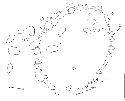
Technical Drawing of Tent Ring (To Scale)